
The Atlas
Maps of the Bible
Twelve published maps of the biblical world and of the church it became. They come from the classic public-domain atlases: George Adam Smith’s Historical Geography of the Holy Land (1915), Bonne’s 1770 engraving of the tribes, and their peers. Each plate is attributed, linked to its source, and opens full-size in a new tab.
Summary
The Bible happens on a small stage. From Dan to Beersheba is about 150 miles, and most of the story fits in that space.
- Dan to Beersheba is about 150 miles. Joppa to Jericho is under 50.
- Every plate here was printed between 1770 and 1926.
- Each caption names the years the plate draws.
- Tribal borders come from town lists, so no printed tribal map is a survey.
- Nobody is sure where Sinai stood. Three sites are argued for.
The Land of the Book
Most of Scripture happens on a stage smaller than many counties.
Gen 12:5–7 · Deut 34:1–4 · Judg 20:1: “from Dan to Beersheba”
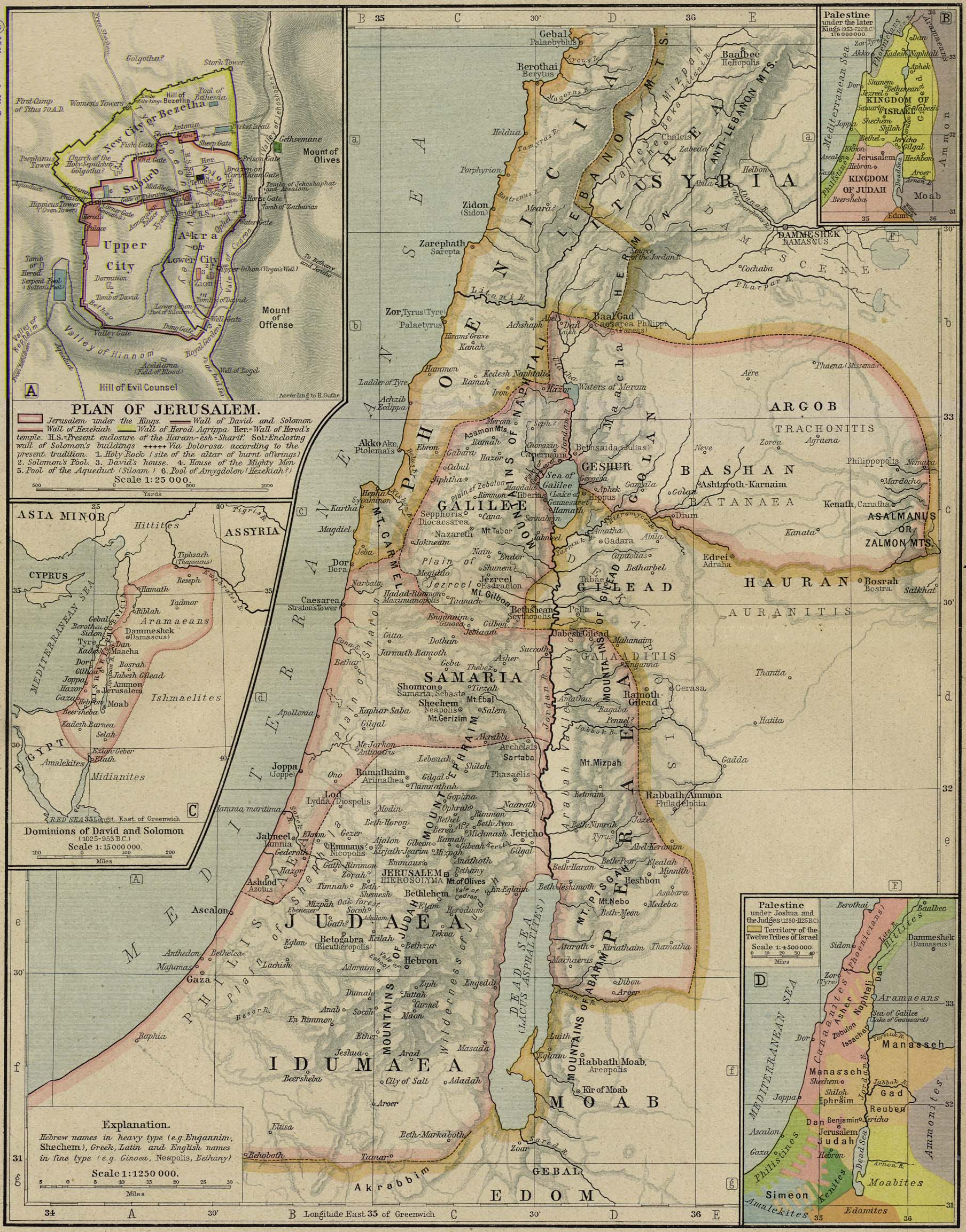
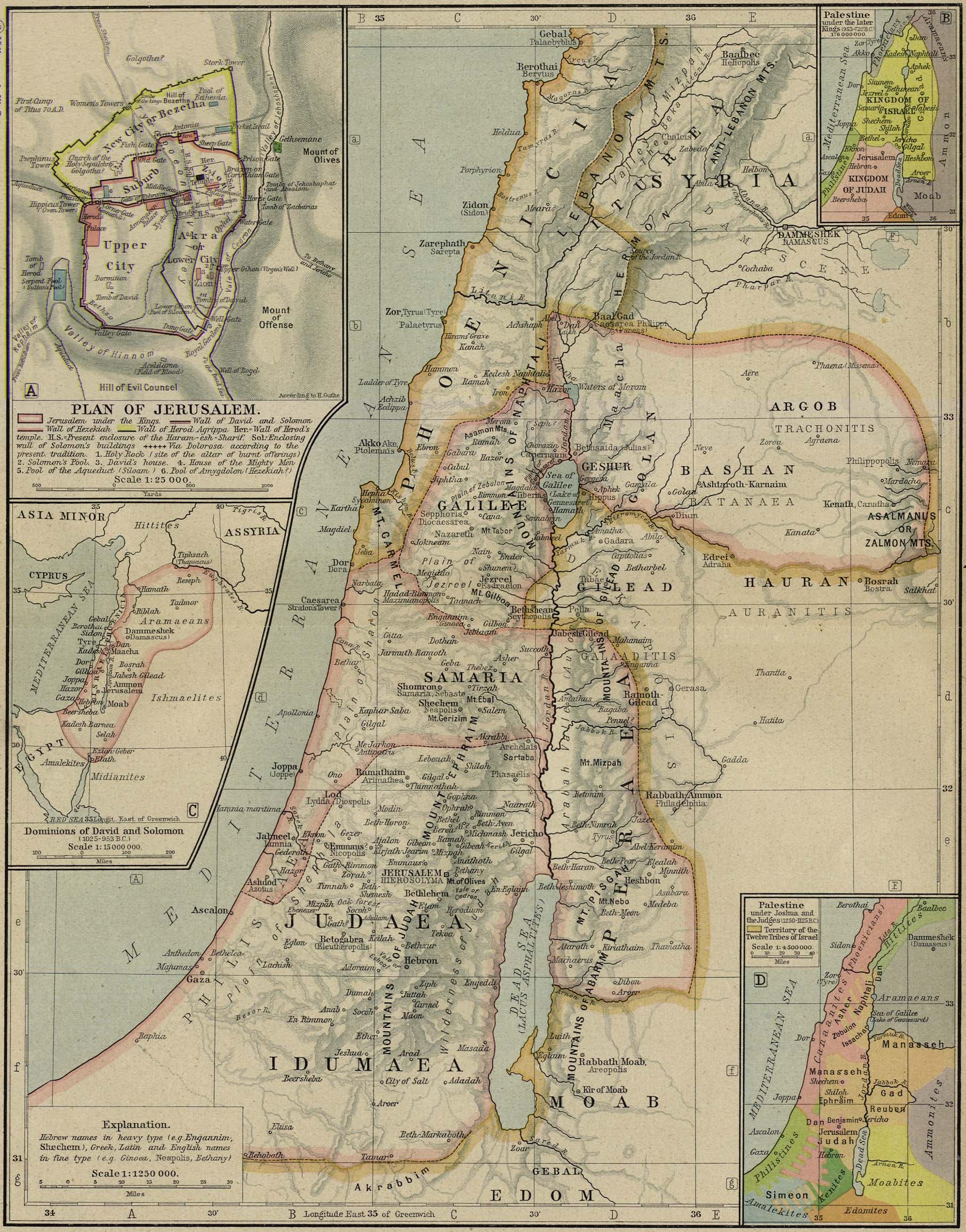
From Dan in the north to Beersheba in the south is about 150 miles; from Joppa on the coast to Jericho in the rift valley, under 50. Almost everything in the historical books happens on this small stage: the coast road and the ridge road, Galilee's lake, the Jordan's deep trench, and Jerusalem on its watershed spine.
The plate draws the land as Scripture describes it, from Genesis to Acts.
The plate: Reference map of ancient Palestine, Rand McNally reference map (1926), public domain
What it cannot fix: This is a 1926 reference sheet, not a map of any single moment. Its Jerusalem inset draws the wall Herod Agrippa built in the AD 40s and marks the Via Dolorosa by present tradition, so the city plan on it is neither Abraham's Salem nor David's Jerusalem.
Licence verified per file. The scan at Wikimedia Commons. Click the plate for the full size.
The Twelve Tribes
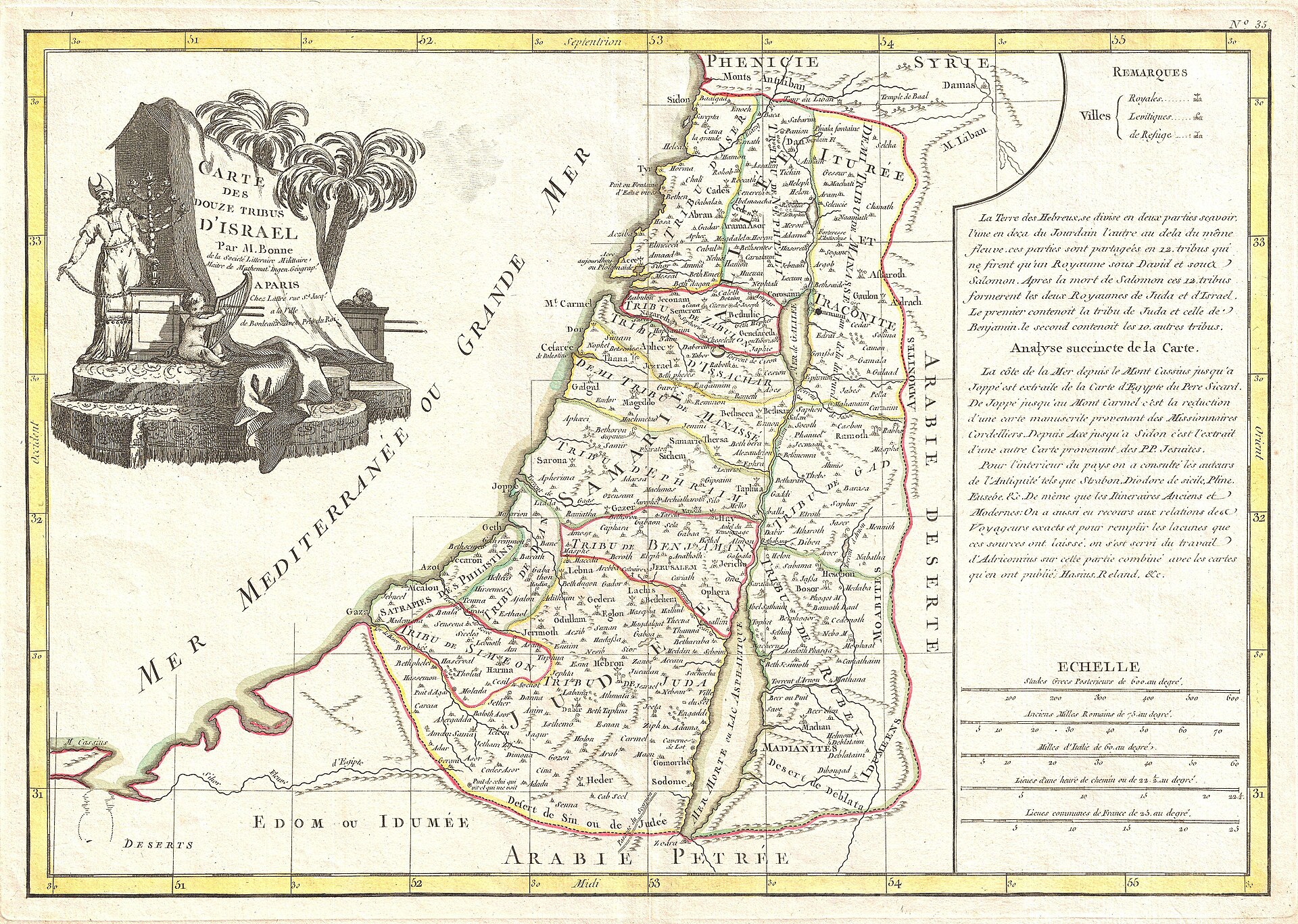
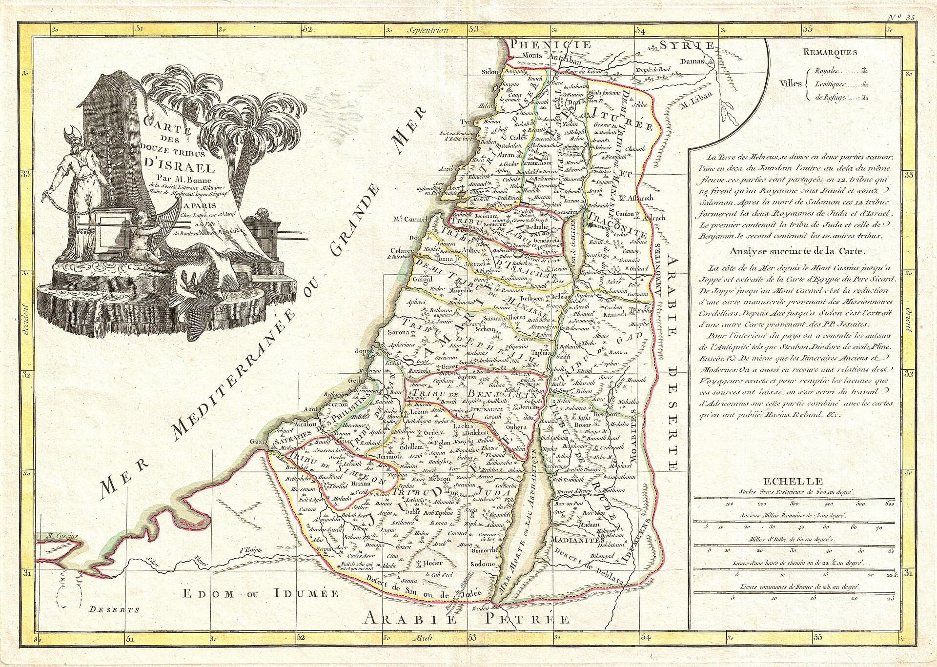
Bonne engraved the allotment under Joshua in 1770.
Josh 13–21 · Gen 49 · Num 26
Joseph's portion is doubled through Ephraim and Manasseh, and Levi receives cities, not territory: which is how twelve tribes yield thirteen names and twelve allotments. The borders in Joshua 13–19 are town-lists, not survey lines; every printed tribal map, this 1770 engraving included, is an approximation.
The plate draws the allotment under Joshua, about 1400 BC.
The plate: The Twelve Tribes of Israel, Rigobert Bonne (1770), public domain
Licence verified per file. The scan at Wikimedia Commons. Click the plate for the full size.
The Exodus Road
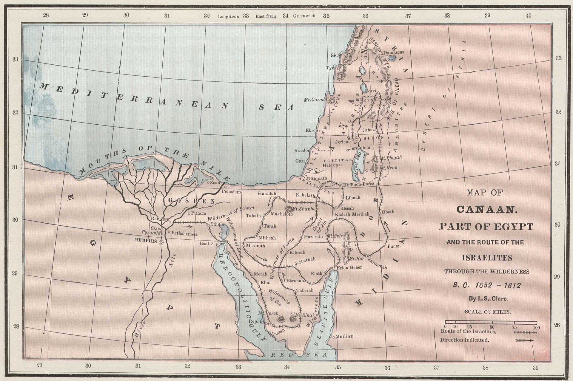
Cram's plate draws Egypt to Canaan through the wilderness.
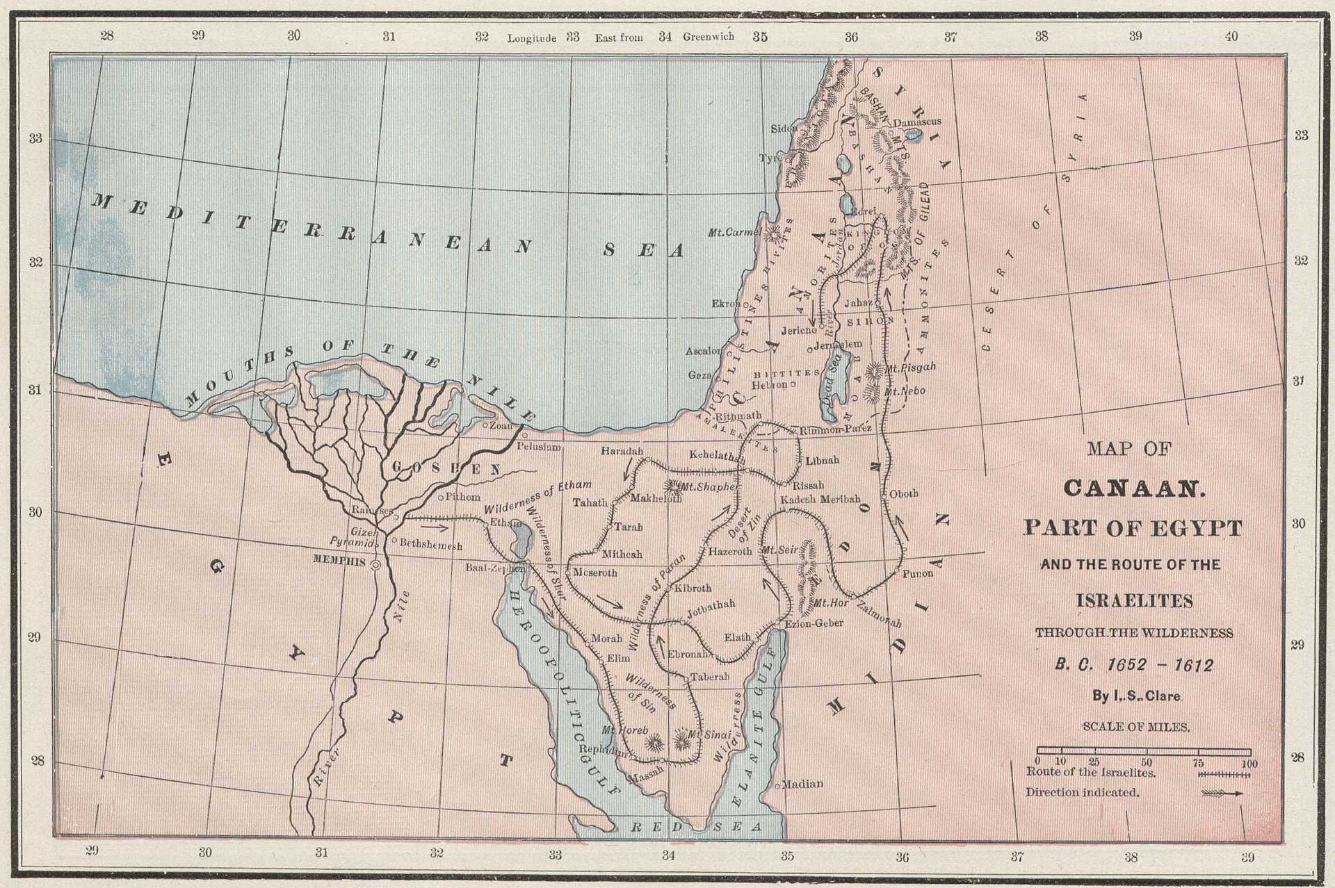
Exod 12:37 · Exod 19:1–2 · Num 33 (the itinerary) · Deut 1:2
Rameses, the sea, Marah's bitter water, Elim's twelve springs, Rephidim, the mountain. Then comes the long way after Kadesh-barnea: thirty-eight years for a road Deuteronomy 1:2 says takes eleven days. It ends on Nebo, with Moses looking across at what Joshua would enter. Scripture's own itinerary is Numbers 33, and the mountain's location is the traditional identification, weighed in the fold below.
The plate draws the road from Egypt to Canaan, which this site dates 1446 to 1406 BC.
The plate: The route of the Israelites through the wilderness, George F. Cram atlas plate, public domain. Its title block dates the exodus B. C. 1652 to 1612, which is an older reckoning than this site's.
What it cannot fix: The plate draws one route to one mountain. Three identifications of Sinai carry the argument, and the fold under this plate weighs all three.
The stations: Numbers 33 records the march as a chain of camps and names thirty-nine of them. The plate draws a line through a few. This site cannot yet say which of the rest can be put on the ground, because it does not carry the identification data that would settle it. No station here is marked either located or lost. The chapter's own list, in its own order, is under the plate.
Licence verified per file. The scan at Wikimedia Commons. Click the plate for the full size.
Where is Mount Sinai?: the contested identificationsExod 3:1; 19:1-2 · Gal 4:25
Scripture locates Sinai “in Arabia” only in Paul’s allegory (Gal 4:25, where “Arabia” in Roman usage included the Sinai peninsula) and never gives coordinates. Three identifications carry the argument. Jebel Musa (south-central Sinai, the route most atlas plates draw) is the traditional site: monastic memory from at least the 4th century (St. Catherine’s), a plain (er-Raha) large enough for an encampment, and a location that fits an itinerary reaching Kadesh-barnea “eleven days’ journey” away (Deut 1:2). Jebel al-Lawz(northwest Saudi Arabia, ancient Midian) is argued from Moses shepherding Jethro’s flocks in Midian when he met the bush (Exod 3:1) and a plainer reading of “Arabia”; its critics answer that Midianite ranges crossed the gulf seasonally, that the proposal’s popular evidences are geological commonplaces, and that it strains the sea-crossing logistics. Northern-route sites (Jebel Sin Bishar and others) fit a shorter itinerary but sit awkwardly with “the way of the wilderness toward the Red Sea” (Exod 13:18). No identification is an article of faith; the events, not the summit’s coordinates, carry the covenant.
The stopping places Numbers 33 names, in the chapter's order39 · Num 33:5-49
The chapter records the march as a chain of camps, naming 39 of them. The plate draws a line through a few. The number beside each name is the verse that names it.
- 1 Succoth 33:5
- 2 Etham 33:6
- 3 Migdol 33:7
- 4 Marah 33:8
- 5 the Red Sea 33:10
- 6 the Desert of Sin 33:11
- 7 Dophkah 33:12
- 8 Alush 33:13
- 9 Rephidim 33:14
- 10 the Wilderness of Sinai 33:15
- 11 Kibroth-hattaavah 33:16
- 12 Hazeroth 33:17
- 13 Rithmah 33:18
- 14 Rimmon-perez 33:19
- 15 Libnah 33:20
- 16 Rissah 33:21
- 17 Kehelathah 33:22
- 18 Mount Shepher 33:23
- 19 Haradah 33:24
- 20 Makheloth 33:25
- 21 Tahath 33:26
- 22 Terah 33:27
- 23 Mithkah 33:28
- 24 Hashmonah 33:29
- 25 Moseroth 33:30
- 26 Bene-jaakan 33:31
- 27 Hor-haggidgad 33:32
- 28 Jotbathah 33:33
- 29 Abronah 33:34
- 30 Ezion-geber 33:35
- 31 Kadesh 33:36
- 32 Mount Hor 33:37
- 33 Zalmonah 33:41
- 34 Punon 33:42
- 35 Oboth 33:43
- 36 Iye-abarim 33:44
- 37 Dibon-gad 33:45
- 38 Almon-diblathaim 33:46
- 39 the Jordan 33:49
The Conquest & the Judges
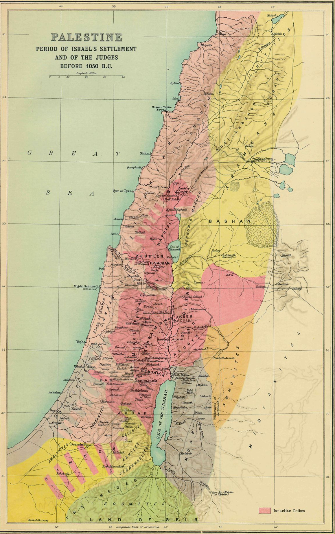
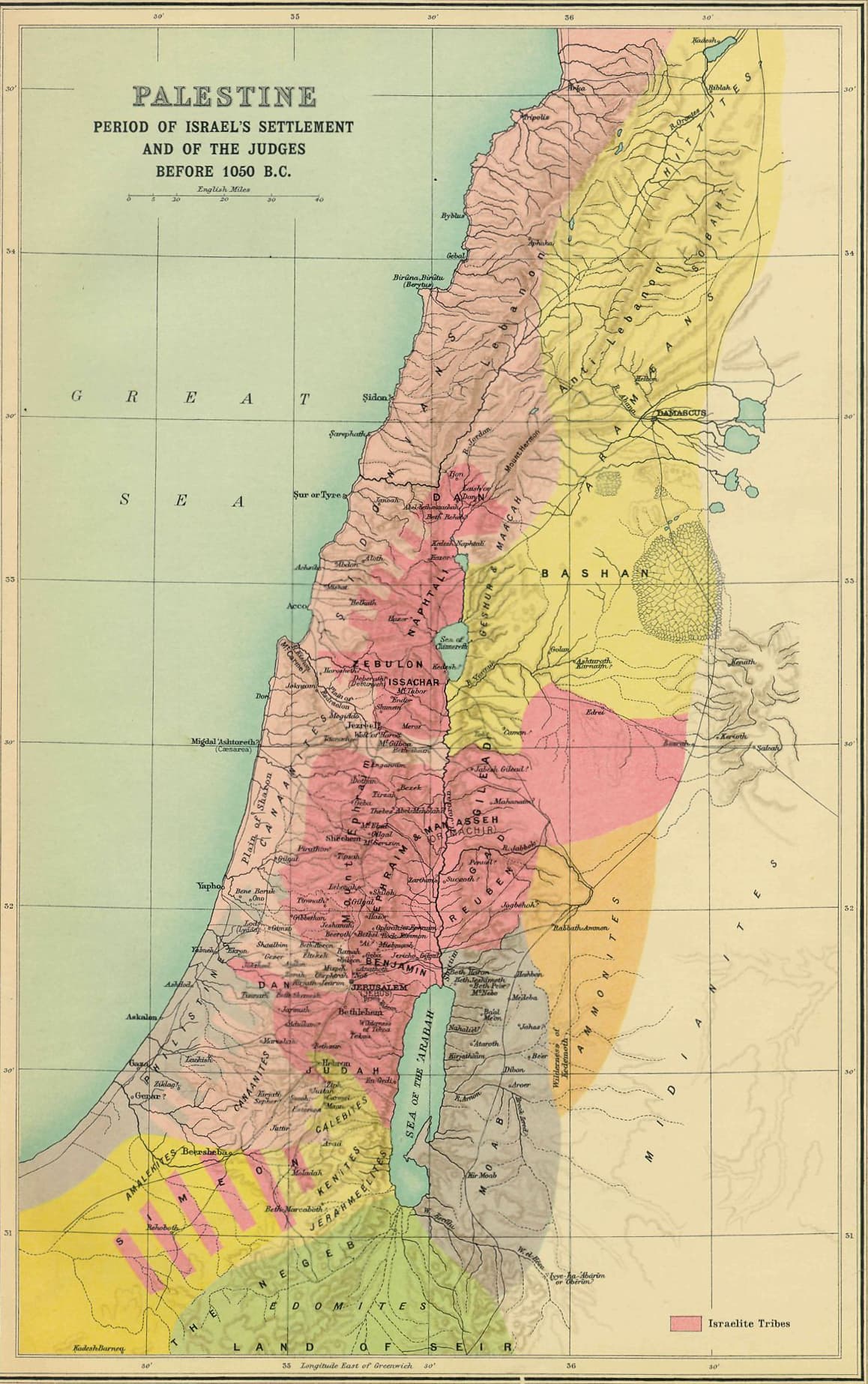
Smith's 1915 atlas draws the land as Israel settled it.
Josh 3–11 · Josh 21:45 · Judg 1–2
Israel crosses the Jordan and camps at Gilgal, the base every campaign returns to. The center falls first (Jericho, Ai, covenant renewed at Ebal and Gerizim); then the south in one forced march after Gibeon; then the north, where Hazor, “the head of all these kingdoms”, burns. Smith's plate shows the land as the settlement left it, including the plains and valleys the tribes failed to take (Judg 1), where the Judges cycle would turn for three centuries.
The plate draws the settlement and the judges, about 1400 to 1050 BC.
The plate: Israel's settlement and the period of the Judges, George Adam Smith, Atlas of the Historical Geography of the Holy Land (1915), public domain
Licence verified per file. The scan at Wikimedia Commons. Click the plate for the full size.
The Kingdom of David & Solomon
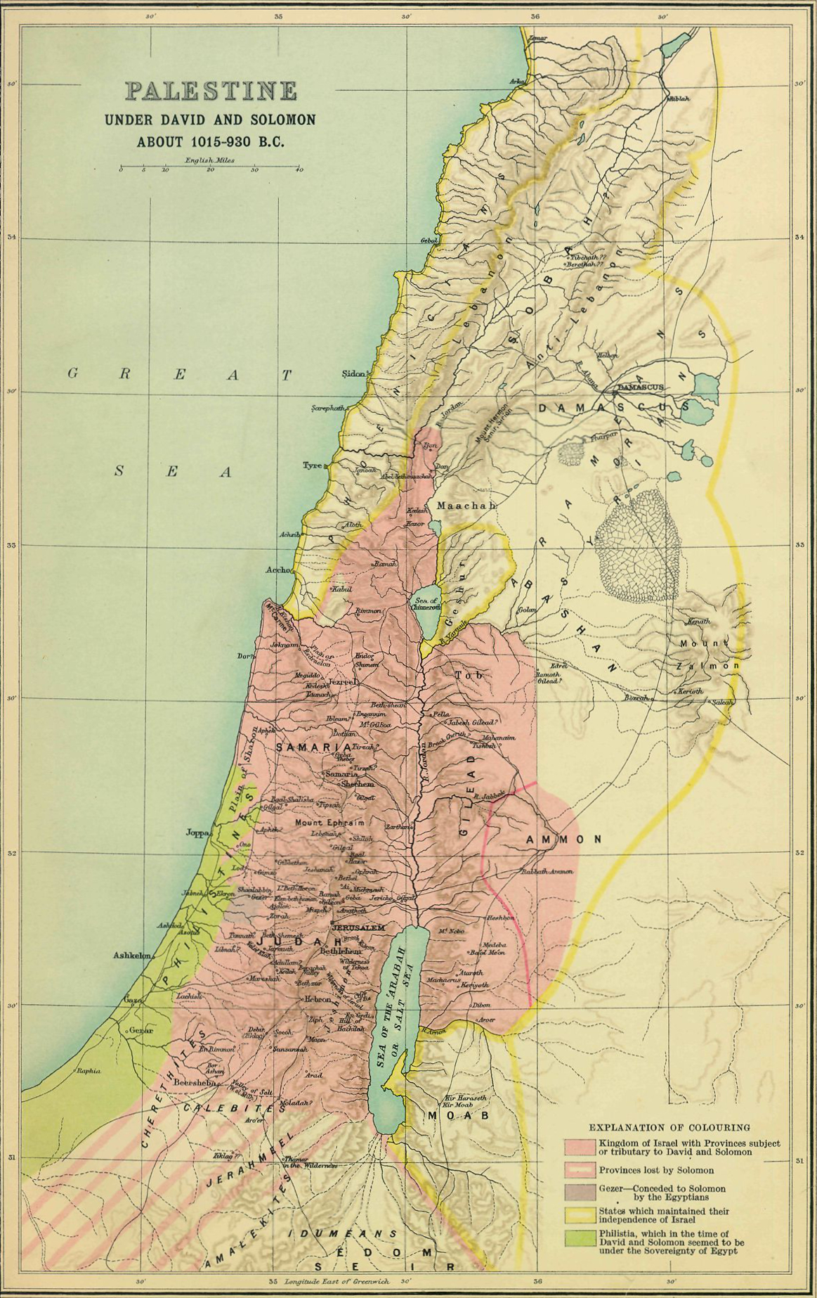
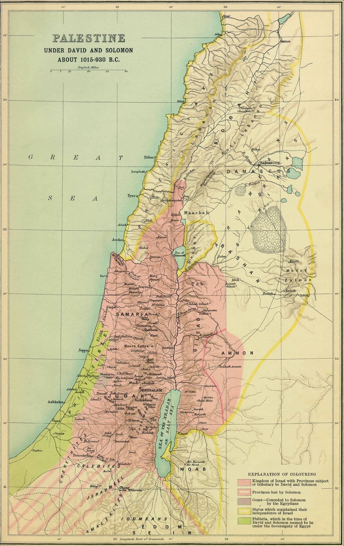
Smith's 1915 atlas draws the united monarchy at its widest reach.
2 Sam 8 · 1 Kgs 4:21-25 · 1 Kgs 9:15-19
David subdues Philistia, Moab, Ammon, Edom, and Aram (2 Sam 8), and Solomon reigns “over all the kingdoms from the Euphrates to the land of the Philistines” (1 Kgs 4:21). Hazor, Megiddo, and Gezer, named in one breath with Jerusalem's wall in 1 Kings 9:15, were excavated with strikingly similar six-chamber gates. The refrain of the golden age: “Judah and Israel dwelt securely from Dan to Beersheba, each man under his own vine and his own fig tree” (1 Kgs 4:25).
The plate draws the united monarchy at its widest, about 1000 to 930 BC.
The plate: Palestine under David and Solomon, George Adam Smith, Atlas of the Historical Geography of the Holy Land (1915), public domain
What it cannot fix: The outer reach on this plate is tribute territory rather than settled land, which is what 2 Samuel 8 describes.
Licence verified per file. The scan at Wikimedia Commons. Click the plate for the full size.
The Divided Kingdom & the Exiles
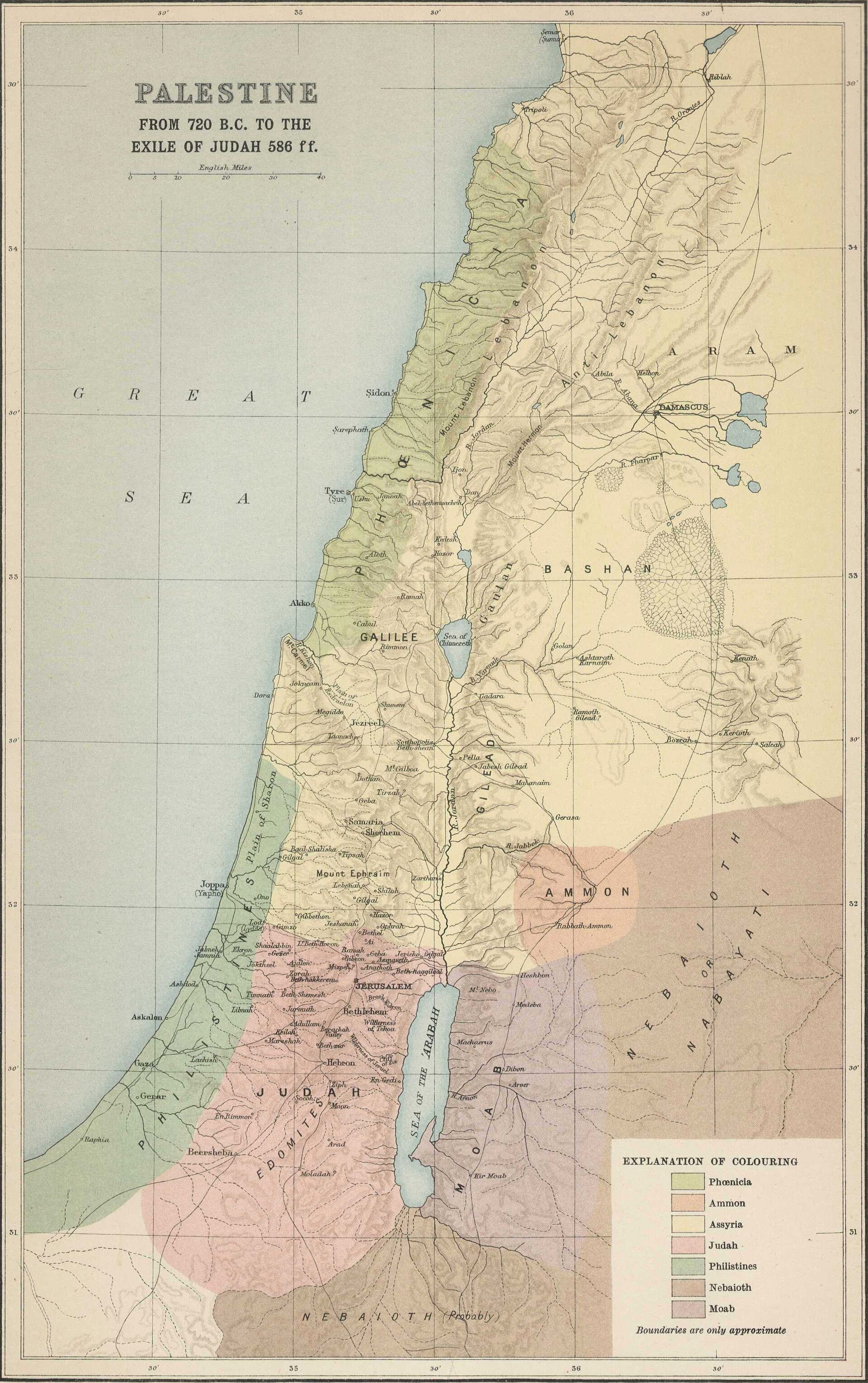
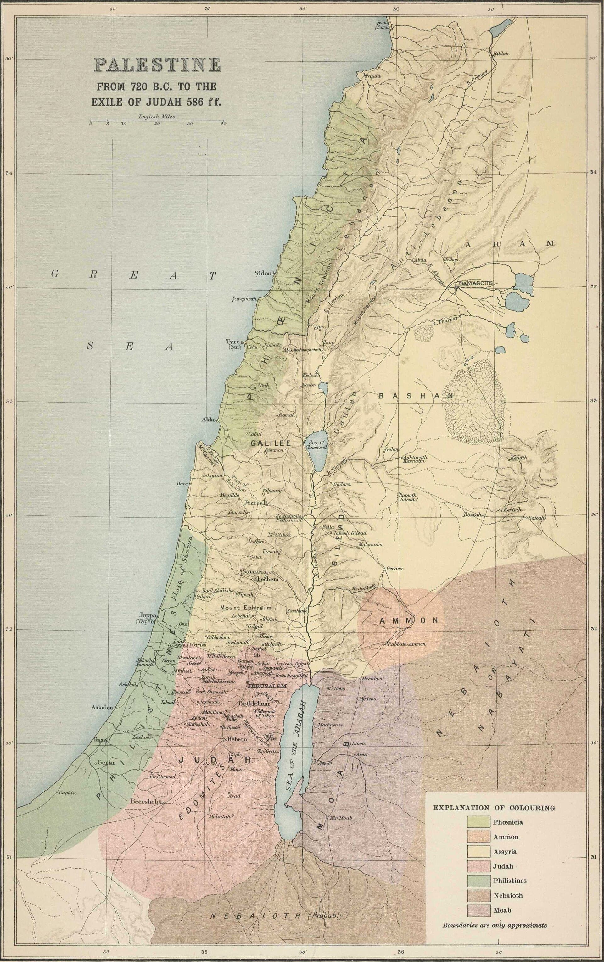
Smith's 1915 atlas draws the deportations from 720 BC to the exile of Judah.
2 Kgs 17:6 · 2 Kgs 24–25 · Dan 1:1 · Ezra 1:1–3 · Jer 29:10
After Solomon the kingdom tears in two: Israel ruled from Samaria, Judah from Jerusalem. Assyria takes the north in 722 BC; Babylon takes the south in three deportations (605, 597, 586). Smith's plate maps the land in exactly this window: the Assyrian provinces standing where Israel had been, Judah alone with its lamp still burning, until Cyrus's decree in 539/538 opens the road home.
The plate draws the deportations to the fall of Jerusalem in 586 BC. Its own title starts them at 720 BC; this site dates Samaria's fall to 722 BC, on Thiele's count.
The plate: Palestine from 720 BC to the exile of Judah, George Adam Smith, Atlas of the Historical Geography of the Holy Land (1915), public domain
Licence verified per file. The scan at Wikimedia Commons. Click the plate for the full size.
The Land in the Time of Christ
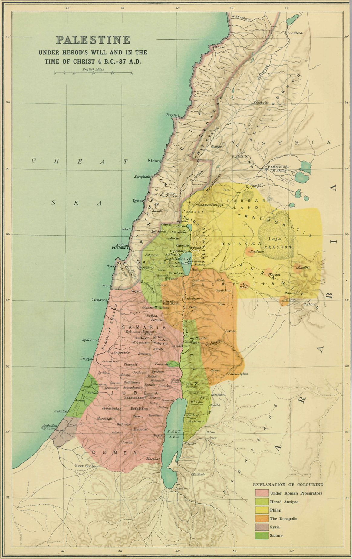
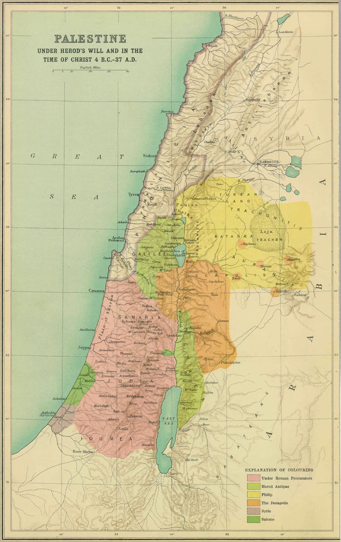
Smith's 1915 atlas draws Herod's legacy and the regions the ministry crossed.
Matt 4:12–17 · John 4:3–4 · Luke 9:51 · Mark 10:32–34
Capernaum, not Nazareth, is the home base of the ministry: Matthew 9:1 calls it “His own town”, on the lake's north shore. South lies Samaria, which John 4:4 says Jesus “had to pass through”, though pilgrims often took the Perean road east of the Jordan instead, which is the route of the final ascent through Jericho. He goes north to Caesarea Philippi for Peter's confession and west to Tyre and Sidon, and every road in the end converges on Jerusalem. Smith's plate shows the tetrarchies as Herod's will carved them, which is the political map every Gospel scene assumes.
The plate draws Herod's tetrarchies, about 4 BC to AD 39.
The plate: Palestine in the time of Christ, George Adam Smith, Atlas of the Historical Geography of the Holy Land (1915), public domain
Licence verified per file. The scan at Wikimedia Commons. Click the plate for the full size.
The Word Spreads: Acts 8–12
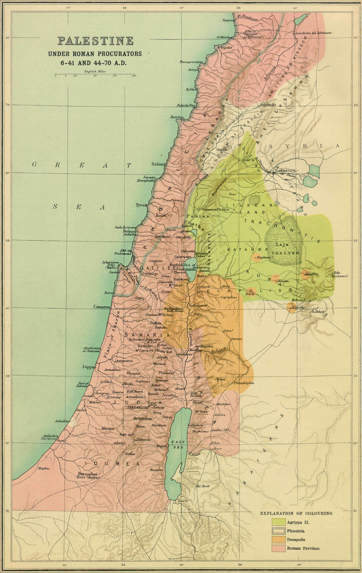
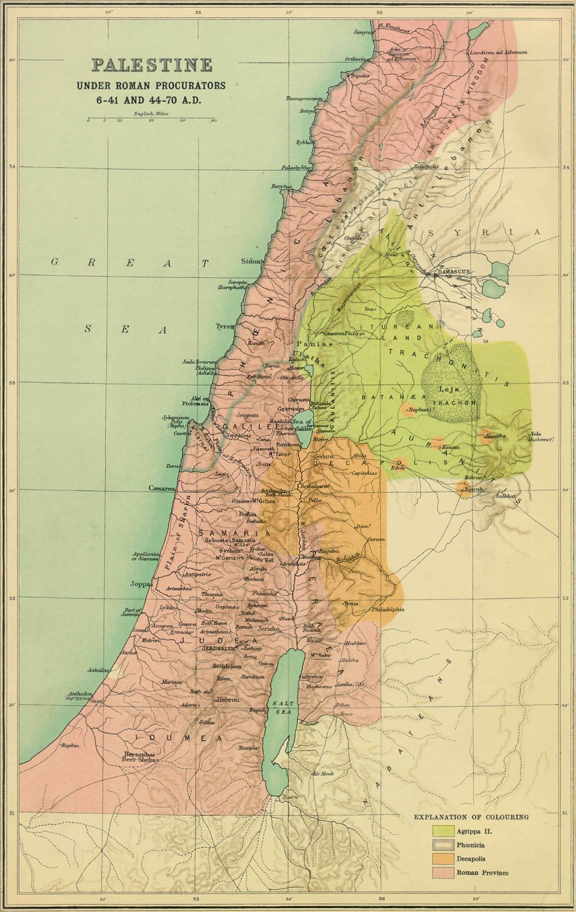
Smith's 1915 atlas draws Judea, Samaria and the coast under the procurators.
Acts 8:1-40 · Acts 9:1-30 · Acts 10 · Acts 11:19-26
Persecution scatters the church: “Those who had been scattered preached the word wherever they went” (Acts 8:4). Philip goes down to Samaria and then south to the Gaza desert road. Peter works the coastal plain at Lydda and Joppa, and at Caesarea the Spirit falls on a Gentile house. Saul rides for Damascus and meets the risen Lord on the way. The scattered walk the Phoenician coast to Antioch, where the disciples are first called Christians. Every voyage on the next map sets out from that city.
The plate draws Judea under the Roman procurators, about AD 30 to 60.
The plate: Palestine under the Roman procurators, George Adam Smith, Atlas of the Historical Geography of the Holy Land (1915), public domain
Licence verified per file. The scan at Wikimedia Commons. Click the plate for the full size.
The Journeys of Paul
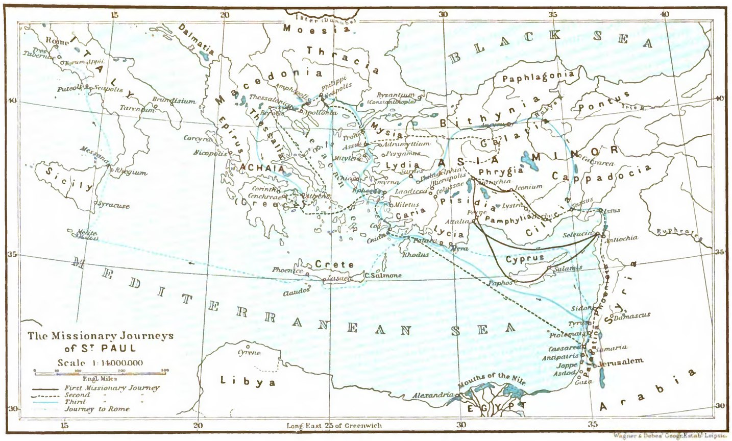
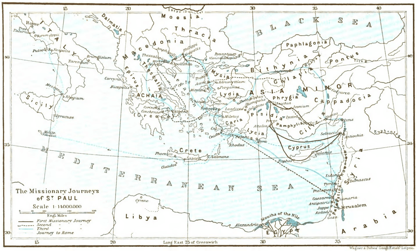
Knecht's plate draws the four voyages Acts records.
Acts 13–14 · Acts 15:36–18:22 · Acts 18:23–21:17 · Acts 27–28
The first tour sails from Antioch through Cyprus into Galatia. The second goes overland through the same churches, then, called through a vision at Troas, crosses into Europe: Philippi, Thessalonica, Berea, Athens, Corinth. The third centers on Ephesus, close on three years. Last comes Acts 27–28: the prisoner's voyage from Caesarea past Crete into the storm, fourteen nights adrift, Malta, and at last Rome.
The plate draws the four voyages and the passage to Rome, about AD 46 to 62.
The plate: The missionary journeys of St. Paul, F. J. Knecht, Practical Commentary on Holy Scripture, public domain. The plate carries no date of its own; Knecht's commentary ran in English editions from 1894.
Licence verified per file. The scan at Wikimedia Commons. Click the plate for the full size.
The Seven Churches of Asia
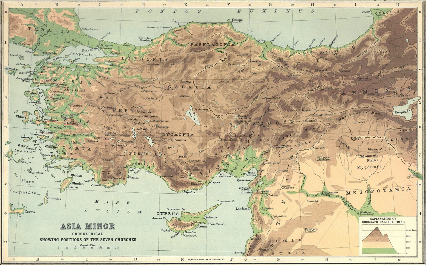
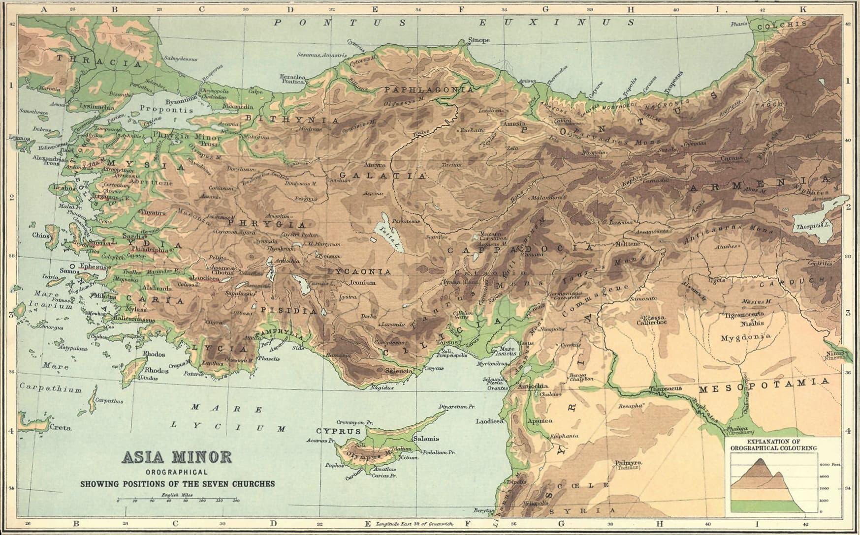
Smith's 1915 atlas draws the postal circuit of Revelation 1 to 3.
Rev 1:9–11 · Rev 2–3
From Patmos, John addresses seven real cities in the order a courier would ride them. The route runs up the coast from Ephesus to Smyrna and Pergamum, then inland and south through Thyatira, Sardis, Philadelphia and Laodicea, which is a natural circuit on the Roman roads. Each of the seven letters opens with a title of Christ and closes with a promise to the one who overcomes.
The plate draws Roman Asia at the close of the first century.
The plate: Asia Minor, showing the positions of the Seven Churches, George Adam Smith, Atlas of the Historical Geography of the Holy Land (1915), public domain
Licence verified per file. The scan at Wikimedia Commons. Click the plate for the full size.
The Apostles' World
Scott engraved the countries the apostles carried the faith into, in 1800.
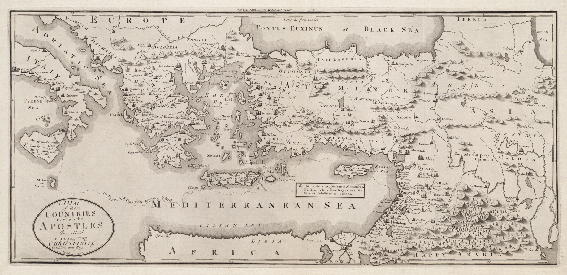
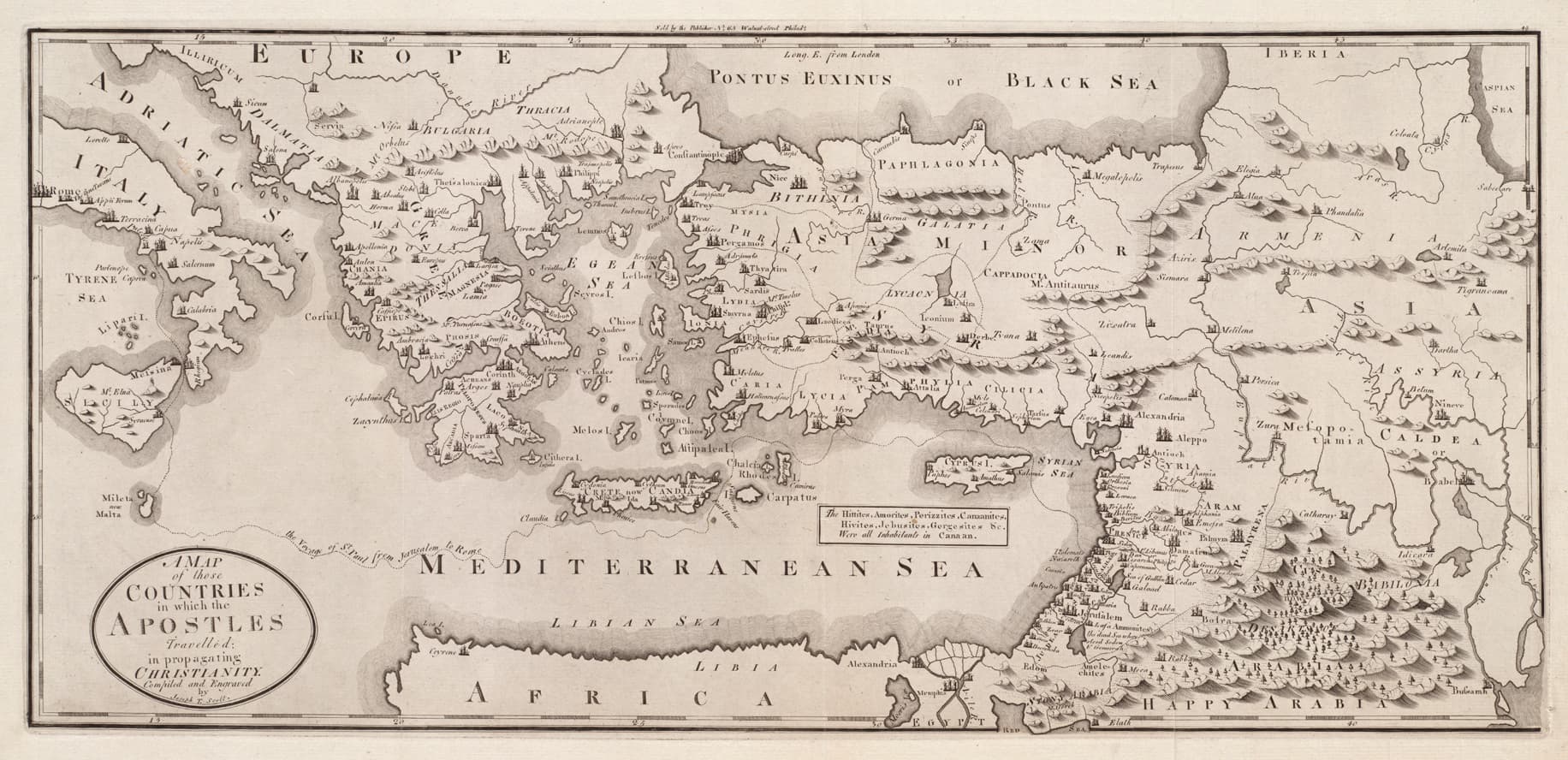
Acts 1:8 · Acts 2:9–11 · Rom 15:19–24 · Col 1:6, 23
The last word before the ascension sets the map: “you will be My witnesses in Jerusalem, and in all Judea and Samaria, and to the ends of the earth” (Acts 1:8). The book of Acts is that sentence unfolding. Scott's 1800 engraving draws the world those witnesses actually walked. It carries the Pentecost nations of Acts 2 and Paul's arc “from Jerusalem all the way around to Illyricum” with Spain in his eye (Rom 15:19). It carries Thomas's road east in the church's earliest memory, and Egypt and Cyrene to the south. Within one generation of the resurrection there were churches on three continents.
The apostles' generation, the first century.
The plate: The countries in which the Apostles travelled in propagating Christianity, Joseph T. Scott (1800), scan CC BY 2.0 via Wikimedia Commons
What it cannot fix: Scott engraved this in 1800, so the coastlines and the place names are an eighteenth-century reading of where the apostles went rather than a record from their own time.
Licence verified per file. The scan at Wikimedia Commons. Click the plate for the full size.
The Spread of the Church
Shepherd's 1923 atlas shades the church's growth era by era.
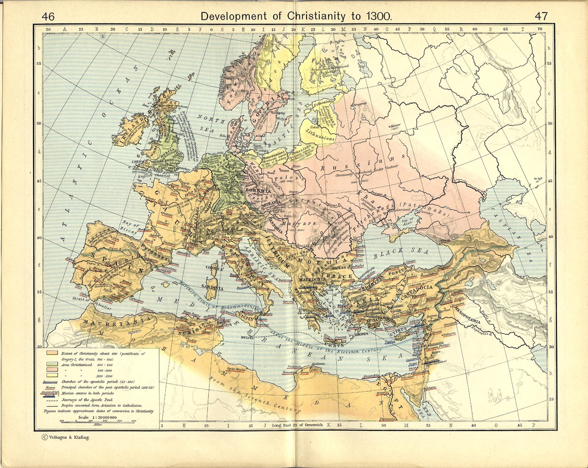
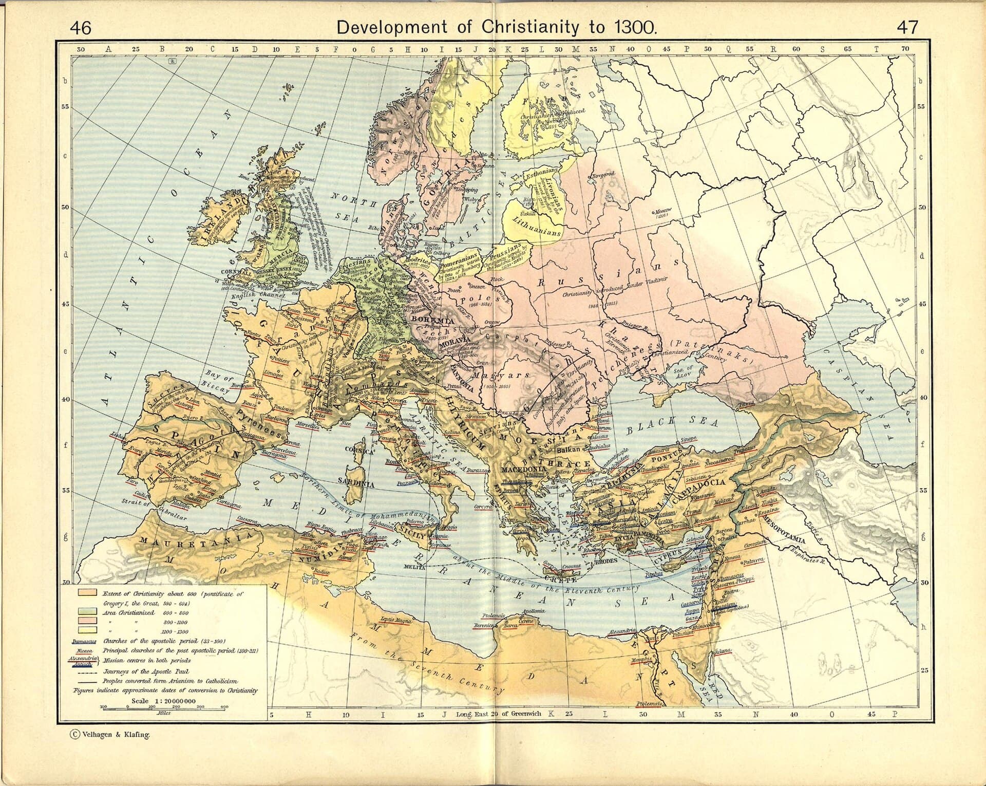
Matt 13:31–33 · Acts 28:30–31 · Rev 7:9
The mustard seed becomes a tree (Matt 13:31–32). Shepherd's plate shades the growth in stages: the scattered congregations of the age of persecution, then the empire-wide church after Constantine. It shades the advances that carried the faith to Ireland, the English, the Germans and the Slavs. It also shades the losses, where the North African and eastern heartlands were overrun in the seventh century. The plate runs to 1300, so the early-church stages are its first shadings. The eras of the Great Cloud of Witnesses walk the same road in people.
The plate shades the church's growth from Pentecost to AD 1300.
The plate: The development of Christianity, William R. Shepherd, Historical Atlas (1923), public domain
What it cannot fix: The plate runs twelve centuries past Acts, so only its first shadings belong to the New Testament; the rest is the church history wing's ground.
Licence verified per file. The scan at Wikimedia Commons. Click the plate for the full size.
Sources: all plates public domain, license verified per file at Wikimedia Commons (linked under each map). George Adam Smith, Atlas of the Historical Geography of the Holy Land (1915); Rigobert Bonne (1770); George F. Cram, on a plate carrying no date; F. J. Knecht, Practical Commentary on Holy Scripture, also on an undated plate, from a commentary that ran in English editions from 1894; Joseph T. Scott (1800); William R. Shepherd (1923); Rand McNally (1926). Scripture frames from the passages cited on each exhibit. Every cited work: the sources registry →